


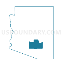
Walker Butte Voting District, Pinal County, Arizona
About
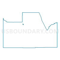
Outline

Summary
| Unique Area Identifier | 525611 |
| Name | Walker Butte Voting District |
| County | Pinal County |
| State | Arizona |
| Area (square miles) | 1.33 |
| Land Area (square miles) | 1.33 |
| Water Area (square miles) | 0.00 |
| % of Land Area | 100.00 |
| % of Water Area | 0.00 |
| Latitude of the Internal Point | 33.14347750 |
| Longtitude of the Internal Point | -111.55583450 |
Maps

Graphs
Select a template below for downloading or customizing gragh for Walker Butte Voting District, Pinal County, Arizona


Neighbors
Neighoring Voting District (by Name) Neighboring Voting District on the Map
- Copper Basin Voting District, Pinal County, AZ
- Florence River Bottom Voting District, Pinal County, AZ
- Johnson Ranch East Voting District, Pinal County, AZ
Top 10 Neighboring County Subdivision (by Population) Neighboring County Subdivision on the Map
Top 10 Neighboring Place (by Population) Neighboring Place on the Map
Top 10 Neighboring Unified School District (by Population) Neighboring Unified School District on the Map
Top 10 Neighboring State Legislative District Lower Chamber (by Population) Neighboring State Legislative District Lower Chamber on the Map
Top 10 Neighboring State Legislative District Upper Chamber (by Population) Neighboring State Legislative District Upper Chamber on the Map
Top 10 Neighboring 111th Congressional District (by Population) Neighboring 111th Congressional District on the Map
Top 10 Neighboring Census Tract (by Population) Neighboring Census Tract on the Map
- Census Tract 2.13, Pinal County, AZ (12,093)
- Census Tract 2.12, Pinal County, AZ (5,970)
- Census Tract 2.11, Pinal County, AZ (4,465)